The Perrinvale Project
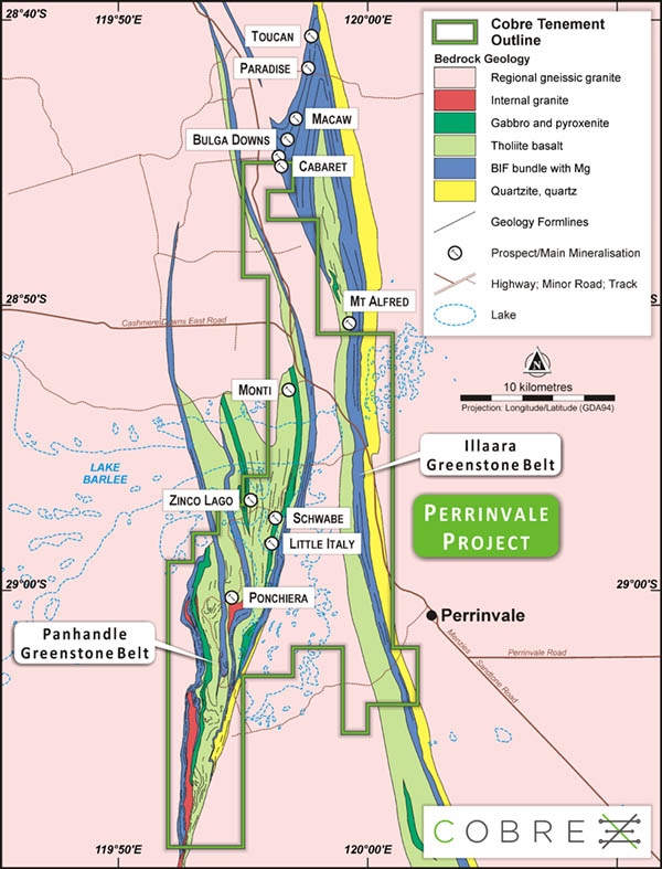
The Perrinvale Project is based on a large conterminous group of nine exploration licenses (and one miscellaneous license) totalling 306km², held by Toucan Gold Pty Ltd (Toucan Gold), a wholly owned subsidiary of Cobre.
The project area is located within the Southern Cross Province of the Yilgarn Craton, approximately midway between the towns of Menzies and Sandstone.
The Perrinvale Project includes the Schwabe Deposit, where the Company has defined a Volcanic Hosted Massive Sulphide Mineral Resource (refer ASX announcement of 5 April 2023).
The Schwabe Prospect
The Schwabe Prospect is located within the rocks of the Panhandle Greenstone Belt (PGB), also known as the South Cook Well Greenstone Belt.
The PGB can be described as a structurally deformed mega-boundin, surrounded by younger regional granites, with the composite stratigraphic sequence being:
- tholeiite basalt, variably pillowed and brecciated, with interflow sediments (uppermost);
- major gabbo sill (600m thick);
- Banded Iron Formation bundle with Magnesium-basalt; and
- muscovite quartzite (lowermost).
The Schwabe Prospect is located within the upper tholeite basalt sequence of the stratigraphy . The VHMS at Schwabe has been interpreted by both Cobre and H&SC as being a mineralised (Zn/Cu/Co/Pb/Ag/Au) volcaniclastic/sedimentary rock sequence of rocks striking ~018° azimuth and dipping west at ~70° to 75°, bounded by basaltic rock in the hanging wall and foot wall (refer Figure 2 and Figure 3). The VHMS zone, as currently defined by drilling and outcrop, ranges between 0.5m to 17m thick, a strike length of ~190m and a down dip extent of ~160m to 180m.
Drilling and field observations around the Schwabe Prospect indicate dominantly mafic and ultramafic volcanic and intrusive rocks and rarer sedimentary rocks. The volcanic rocks include basalts (tholeiites, hi-Mg basalts and komatiitic basalts) and the lithofacies range from coherent, to pillowed, to autoclastic (hyaloclastites and peperites). The base-metal sulphide intersections are dominantly associated with sedimentary facies (mudstones, black shales and cherts) and some of the sulphide
textures indicate seafloor or near-seafloor deposition within these sedimentary units.
Maiden Mineral Resource Estimate
Table 1: Schwabe MRE showing tonnage, grade and contained metal at a 0.2% Cu cut-off grade
| Category | Kt | Density (t/m3) |
Grade | Contained Metal | ||||||||||
| Cu % |
Zn % |
Co % |
Pb % |
Au ppm |
Ag ppm |
Cu tonnes |
Zn tonnes |
Co tonnes |
Pb tonnes |
Au oz |
Ag oz |
|||
| Indicated | 115 | 3 | 2 | 1.6 | 0.05 | 0.04 | 0.54 | 7.99 | 2,320 | 1,810 | 50 | 60 | 1,990 | 29,650 |
| Inferred | 157 | 2.9 | 1.2 | 1 | 0.03 | 0.03 | 0.33 | 5 | 1,920 | 1,550 | 50 | 50 | 1,680 | 25,240 |
| Total MRE | 272 | 2.9 | 1.6 | 1.2 | 0.04 | 0.03 | 0.42 | 6.27 | 4,240 | 3,360 | 90 | 103 | 3,670 | 54,890 |
Notes:
- Numbers may not total due to rounding and reporting to appropriate level of significant figures
- Refer to ASX Announcement dated 5th April 2023 – Perrinvale VHMS Project Maiden Mineral Resource


